Zuluk Travel Guide
Are you a traveler who loves to explore the less visited and somewhat off-beat places? If the answer is yes, then Zuluk is a perfect place for you to plan a visit.
Zuluk entered the tourist map of Sikkim just a few years back. Being a off-beat place located in East Sikkim you will need to plan well in order to make the visit a memorable one.
This guide will provide all the required information that you need to plan your Zuluk visit.
Ready for that?
For creating a good plan that suits your travel style and personal preferences, you need to understand –
– Zuluk overview
– How to reach Zuluk
– Zuluk weather and temperature
– What to see
– What to do
Overview
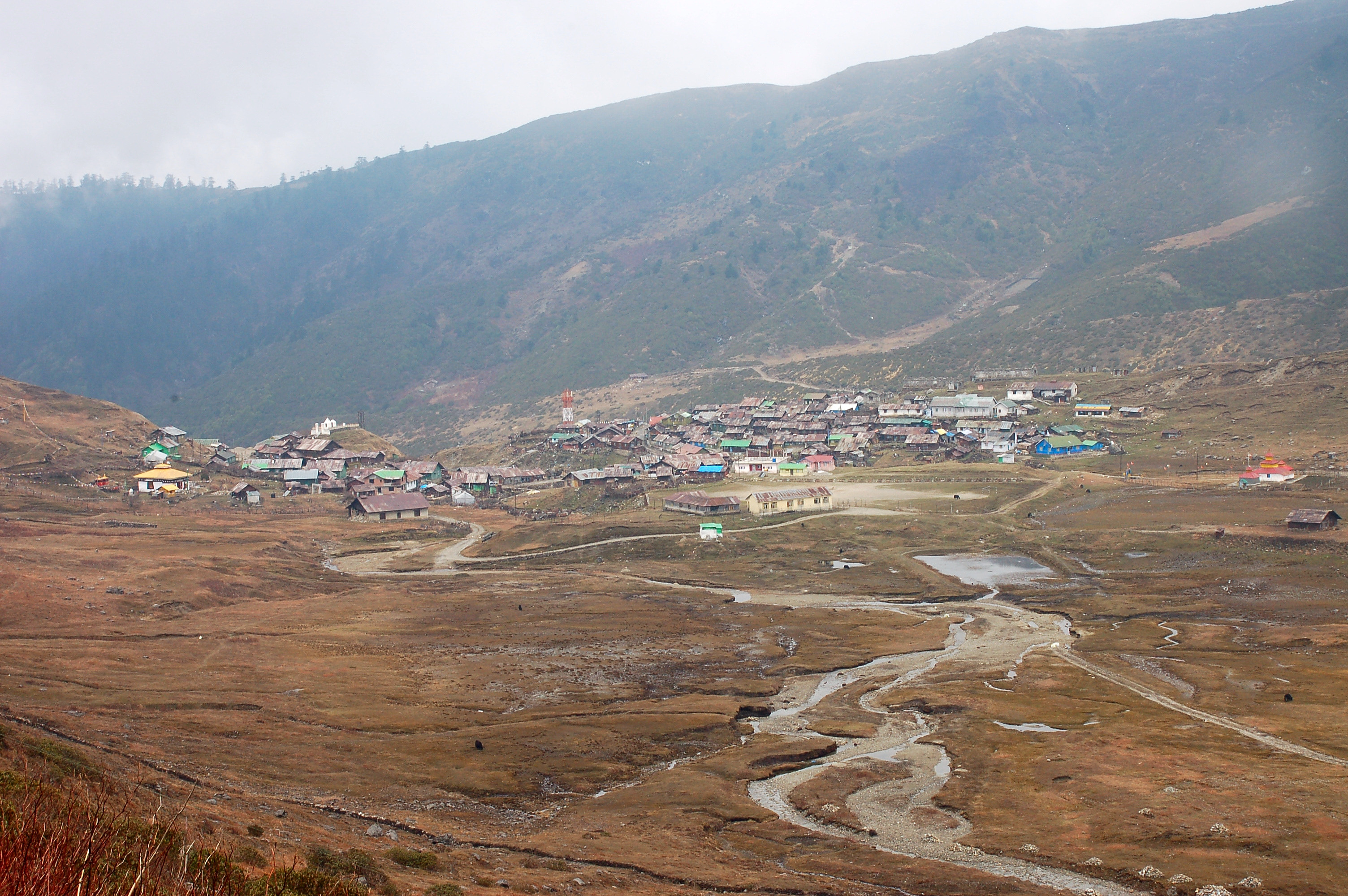
Zuluk also known as Dzuluk, Jhuluk or Jaluk is a peaceful Himalayan village located at a height of nearly 10,000 feet on the rugged terrain of lower Himalayas in the East Sikkim Area. Till recently, several travel restrictions were in place and visiting Zuluk was not easy. Now, Indian tourists can get a restricted area permit easily and travel to this region.
Zuluk is located on the famous Silk Route which connects Lhasa (Tibet) to Pedong (near Kalimpong). This village used to be the night halt of the traders before entering Tibet via Jelep-La pass. The route was used by the traders until a few decades ago when the Chinese invaded Tibet.
Now a days, most tourists use Zuluk as a base for traveling in the silk route region and visit places like Nathang Valley, Kupup Lake, Jelep-La pass, Old Baba Mandir and Tsongmo Lake. All these places are located on the Zuluk to Gangtok route. After a night stay at Zuluk, tourists may proceed to Gangtok visiting these places on the way.
Main attraction of Zuluk and this region is the unrestricted view of Mt Kanchenjunga range of the Himalayas. On a clear sunny day, you will get a magnificent view of the entire Kanchenjunga range. During summer, the region is flooded with colorful rhododendrons and other flowers.
Zuluk is surrounded by dense forests. Many parts of these forests are completely virgin. Wild dog, deer, red panda and Himalayan bear are some of the common animals found here. In addition, you can also see birds like Blood Pleasant, Snow Pleasant, Khaleez Pleasant and Monal Pleasant.
Zuluk has a large army base camp. Due to close proximity to the Jelep-La pass and Chinese border this region is very important for national security purpose. Therefore, a strong contingent of army remains in this region throughout the year.
How To Reach Zuluk
Nearest airport for Zuluk is Bagdogra and nearest major railway station is New Jalpaiguri. From both the places, Zuluk is around 140 km by road.
Bagdogra and New Jalpaiguri is well connected via air and rail from most of the major cities of India. Once you reach either of these two nearby places, you will proceed further towards Zuluk.
Though there are local buses available, having a car for this route will be most convenient for the tourists. Depending on no of people in the group, one may hire a car that will comfortably accommodate all the people. A SUV type car or a jeep is preferred in this route. If you are planning on a limited budget, look for point to point share jeeps.
From Bagdogra or New Jalpaiguri, most common route for Zuluk is via NH 10 till Rangpo. From Rangpo, the route goes via Rorathang – Rhenock – Lingtam – Rongli Bazar – Padamchen. It takes around 6 hrs to reach Zuluk via this route. Restricted area permit required for Zuluk is issued from Rongli Bazar. It will be a good idea to visit the beautiful Aritar Lake on the way.
Distance of Zuluk
From | Distance (KM) |
|---|---|
Kolkata | 698 |
Siliguri | 140 |
Gangtok | 68 |
Aritar Lake | 45 |
Nathang Valley | 23 |
Zuluk Weather
Zuluk Temperature
Max temperature (C) | Min Temperature (c) | Average Rainfall (mM) | |
|---|---|---|---|
Jan | 12.3 | 4.0 | 30.9 |
Feb | 13.7 | 5.2 | 79.1 |
Mar | 18.3 | 8.7 | 116.0 |
Apr | 20.9 | 11.3 | 289.2 |
May | 21.6 | 13.4 | 552.6 |
Jun | 22.2 | 15.9 | 603.1 |
Jul | 22.0 | 16.5 | 649.6 |
Aug | 22.4 | 16.4 | 574.0 |
Sep | 21.6 | 15.3 | 487.7 |
Oct | 20.7 | 12.1 | 181.1 |
Nov | 17.6 | 8.5 | 40.0 |
Dec | 14.1 | 5.4 | 22.7 |
Best Time To Visit Zuluk
October – November (Autumn)
Autumn is the best time to visit Zuluk and silk route. The sky remains clear giving you a magnificent view of the mountain peaks. Temperature is on the cooler side but not unbearable. Also, less chances of road blocks due to landslide or snow.
December – February (Winter)
Zuluk and silk route experiences extreme cold during winter. Zuluk remains under snow cover with regular snow fall happening. Road blocks due to snow is very common. Overall, not a very good season for tourism.
March – May (Spring/Summer) Spring/summer is a decent time to visit Zuluk. The valley becomes green again and Rhododendrons come up every where. Many a times, the sky remains foggy or cloudy. This blocks the clear view of mountain range.
June – September (Monsoon)
Monsoon season is not favorable for the tourists. Heavy rainfall happens in this region. Often there are landslides and road closures that restrict traffic.
What To See In Zuluk
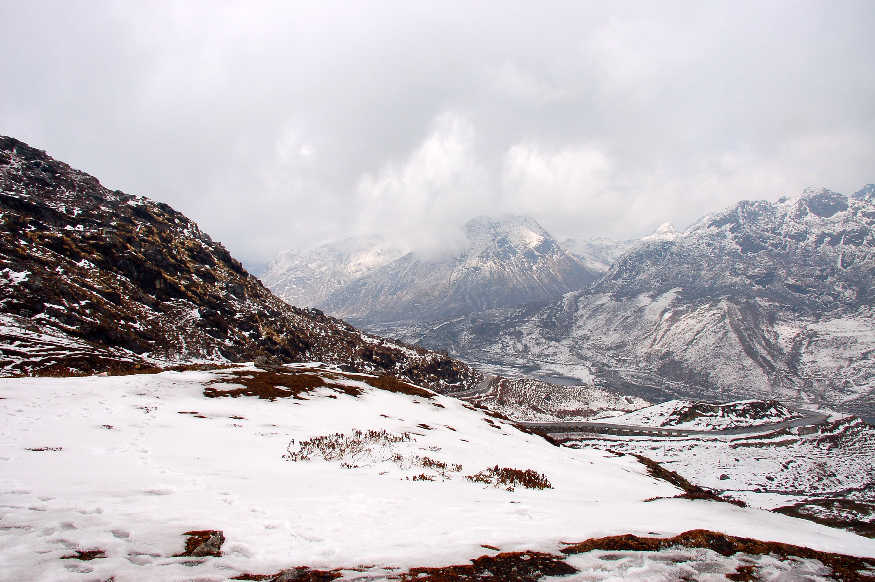
Nathang Valley
Nathang valley or Gnathang valley is popularly known as the Ladakh of East India. Situated at height of 13,500 feet this place is the most beautiful place in the old silk route. This place is surrounded with snow covered mountains and other beautiful landscape due to which it offers an excellent and outstanding view of Mount Kanchenjunga. From here Mount Kanchenjunga is seen at a stone throwing distance.
Along with all the natural beauty, Chinese army watch towers are clearly visible from this place. A small number of people lives in the village. During the winter season this place becomes a white dessert as it is covered with good amount of snow because of regular snowfall taking place. It is difficult to describe the beauty of Nathang valley in one word but this place is something that will make your entire journey unforgettable.
Thambi View Point
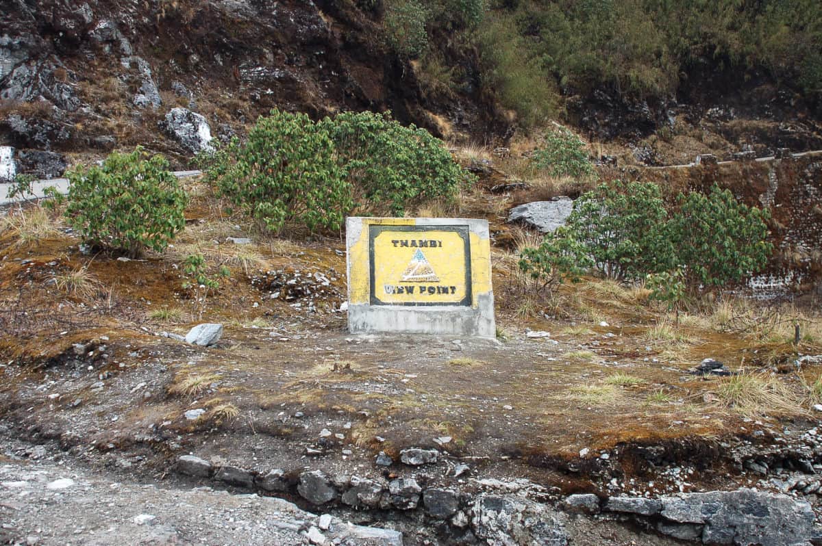
Thambi View Point is located only a few kilometers away from north of the Zuluk and is a must visit place. The journey to Thambi passes through a steep and winding road. The roads and the bends together make a geometric curve due to which travelers experience thrill. It is located at height of 10,200 feet above the sea level.
From here you can get the best and excellent view of sunrise and can also enjoy Eastern Himalayas which can be seen clearly from the top peak. The roads here are in zig-zag shape which need to be crossed anyhow to reach this place. While passing through this you can also stop at one of the famous point where it is said that many local people have seen Yeti.
Kupup Lake
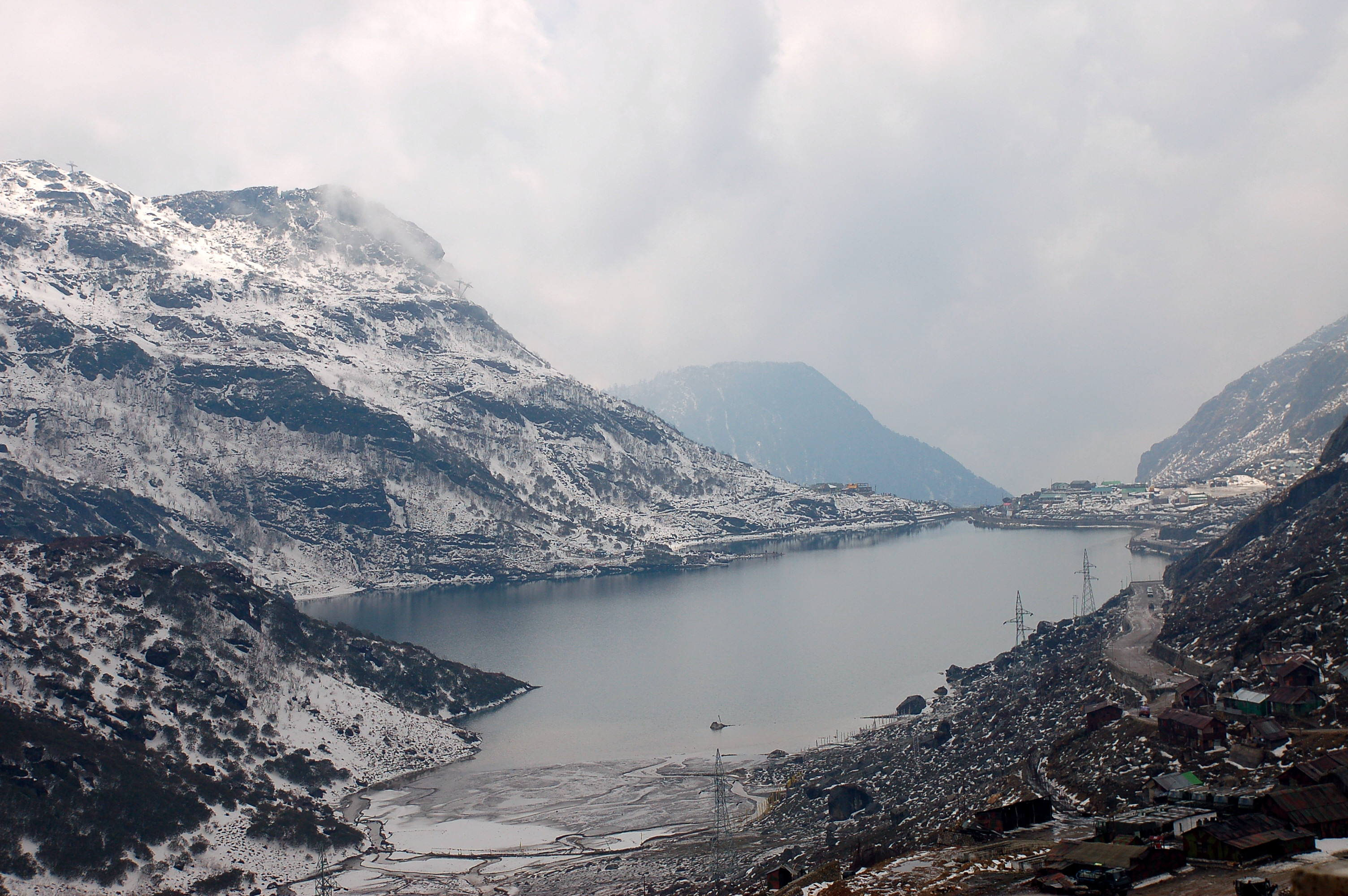
Kupup Lake is one of the most important places on the old silk route and is located near Tulka valley. Moreover, this is the highest village of this region. It was also a major center in the trade which takes place between Tibet and India. In addition, an environmental park is also developed here.
From here China border and Jelep La pass can be seen. In addition, tourist can also enjoy the market and can buy handicrafts for relatives and friends. Kulup also have a golf course and ice hockey field which is located at an altitude of 13,025 feet.
Old Baba Mandir
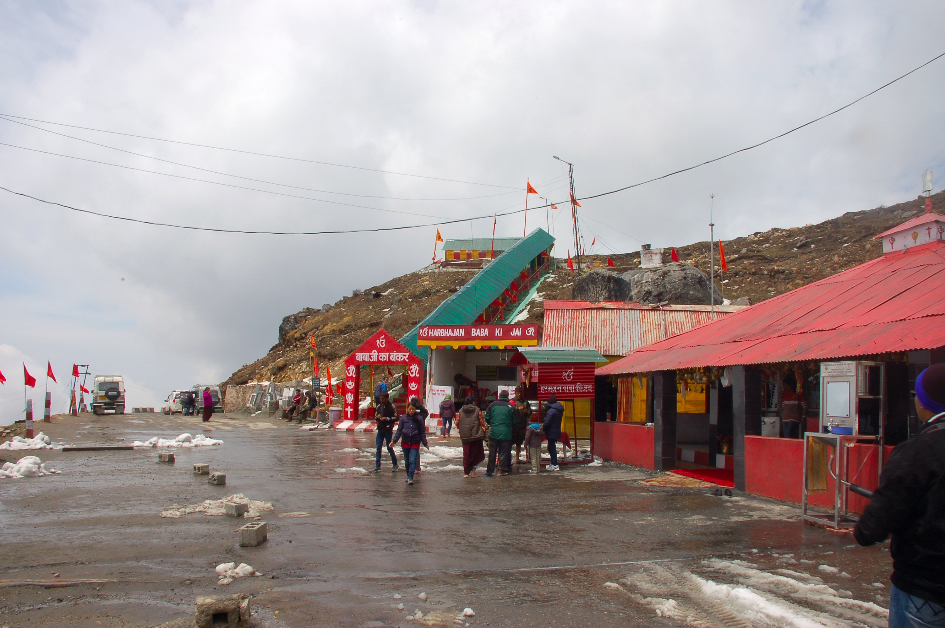
This is a must visit place in old silk route. Old Baba Mandir is also known as Adi Baba Mandir and is dedicated to Baba Harbhajan Singh who was sepoy in 23rdregiment and died near the Lathu LA during the Indo china war in 1962.
This temple is looked after by army officers and they take care of it. In fact it is believed that those army people who serves in the temple get favors from Baba. At this temple a camp bed is also kept and the uniform and boots are polished regularly. Most of the time the bed sheets are seen crumbled in the morning and the boots are noticed muddy by evening. The Indian army offers Prasad and tea to all the visitors those who visit this place
Hathipokhri Lake
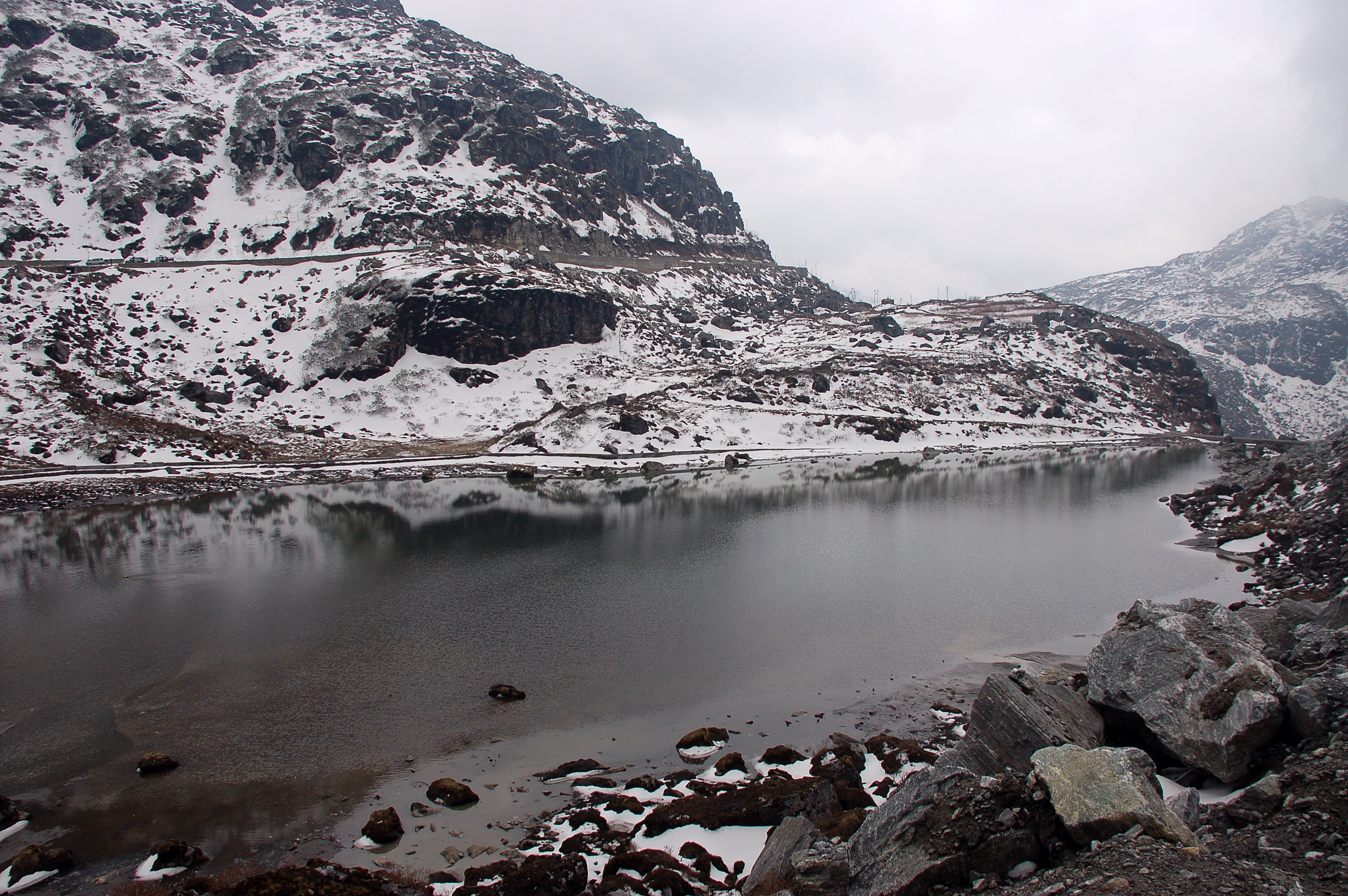
This Lake is also known as Elephant Lake due to is shape. Hathipokhri is one of the most beautiful lakes and is located near Kupup Lake
Lungthang
This place is located at an altitude of about 12,400 feet above the sea level. Here you will get the best view of Eastern Himalayas. There is ice hockey field at this place. In addition, you can also enjoy the wild birds and other different types of animals. The complete area of Lungthang is controlled by the Indian army and patrolled all day and night
Zuluk Itinerary
From a short visit to a lengthy leisure one – plan your travel that suits you best. Explore various options provided below to chose the best one for you !
These are some of the most popular itineraries suggested by IndiaTravelPage. Chose our recommended plan to explore, or make your own way with a custom travel plan
Explore In 1 Day
Day 1:
Reach Zuluk and put up in one of the available home stays. If you have time, walk to Balasura point to watch the sunset.
Next morning, go out for the silk route trail and visit Thambi View point, Laxmi Chowk, Zig Zag point, Gnathang Valley, Kalapokhari Lake, Old Baba Mandir, Tukla valley, Jepepla Pass View, Kupup Village (World’s highest Golf course), Hathi Pokhari Lake, New Baba Mandir and reach Tsangu Lake. After spending some time at Tsangu and having lunch, proceed for Gangtok.
Explore In 2 Day (Recommended)
Day 1:
After you reach Zuluk and put up in one of the available home stays. If you have time, walk to Balasura point to watch the sunset.
Day 2:
Go out for the silk route trail and visit Thambi View point, Laxmi Chowk, Zig Zag point, Gnathang Valley, Kalapokhari Lake, Old Baba Mandir, Tukla valley, Jepepla Pass View, Kupup Village (World’s highest Golf course), Hathi Pokhari Lake, New Baba Mandir and reach Tsangu Lake. After spending some time at Tsangu and having lunch return back to Zuluk.
Next morning, if you get a clear weather, go for the sunrise point to watch a spectacular sunrise on the majestic Mt Kanchenjunga
Explore In 3 Day
Day 1:
Reach Zuluk and put up in one of the available home stays. If you have time, walk to Balasura point to watch the sunset.
Day 2:
Go out for the silk route trail and visit Thambi View point, Laxmi Chowk, Zig Zag point, Gnathang Valley, Kalapokhari Lake, Old Baba Mandir, Tukla valley, Jepepla Pass View, Kupup Village (World’s highest Golf course), Hathi Pokhari Lake, New Baba Mandir and reach Tsangu Lake. After spending some time at Tsangu and having lunch return back to Zuluk.
Day 3:
Next morning, if you get a clear weather, go for the sunrise point to watch a spectacular sunrise on the majestic Mount Kanchenjunga. Rest of the day is free for you to enjoy this small and remote Himalayan village
Zuluk Tour Plans

What To Do In Zuluk
- Enjoy the peace and tranquility of a small mountain village.
- Visit Nathang Vally and other sight seeing spots
- Enjoy the beauty of the zig-zag road from Zuluk to Nathang Valley
Where to Eat In Zuluk
The are no good restaurants at Zuluk apart from a couple of road side tea stalls. They also serve noodles and biscuits. The homestays serve food to the tourists. Apart from breakfast, they offer basic dishes of vegetables, egg and chicken. Often the food charge is included in the package.
What To Buy In Zuluk
Zuluk is a remote place which was used as a place for night halt by the traders who used to travel in this route. Naturally, the place is not for the shopaholics and there is nothing special that you can buy from here.
How To Get Around Zuluk
To get around the place and visit other places of interests adjacent to Zuluk, the only option for tourists is a vehicle on rental. This route doesn’t have a regular bus route and locals need to depend on the shared jeep services. These shared services are not regular and tourists should not rely on them.
Frequently Asked Questions
Zuluk is very near to the sensitive Indo-China border. Indian nationals require a Special Area Permit to visit Zuluk and Silk Route region. Due to security reason, currently non-Indians are not allowed to visit Zuluk and Silk Route.
Special Area Permit is issued from Sikkim Tourism Office at Gangtok and SDPO office at Rongli. There is a slight difference between the permits issued from Gangtok and Rongli. With the permit issued from Gangtok, tourists can visit Silk Route and also Nathula Pass. The permit issued from Rongli allows a visit only to the Silk Route region and not to the Nathula Pass.
To obtain the permit, adult visitors need two copies of passport size photograph. In addition, photocopy and original of a government photo ID card like Voter Card, Passport or Driving License is required. Please note that Aadhar Card or Pan Card is not accepted as a valid proof. Visitors who are below 18 years of age need Birth Certificate as a proof for the permit.
The permit is not difficult to obtain if the documents are correct. Your vehicle driver can help you to get the permit quickly.
For more details and latest update, please check the official Sikkim Tourism website.
Zuluk and Silk Route is very near to the sensitive India-China border. Due to security reason, currently non-Indian nationals are not allowed to visit Zuluk and Silk Route
There are no hotels to stay at Zuluk and the entire Silk Route region. Homestays run by local villagers are the only lodging option. These homestays offer basic quality of rooms. Rooms are clean and equipped with electricity, English style toilets and basic furniture.
These homestays also offer home made food. Vegetable, egg and chicken is offered in the menu.
It is better to travel from Zuluk to Gangtok side rather than from Gangtok to Zuluk.
The weather in this high altitude area generally remains clear in the morning hours and becomes cloudy in the afternoon. Most of the sightseeing spots on the Silk Route are located within 30-35 km from Zuluk. So, chances of visiting the sightseeing spots in clear weather are more when you are starting from Zuluk. If you are coming from Gangtok, it will be past afternoon when you will reach those spots.
Nathang Valley is located at a height of 13500 ft above sea level. It is a high altitude valley located very close to the Chinese border.
Elevation of Zuluk is 9400 ft above sea level.
Zuluk is located at a distance of 42 km from Aritar Lake. By car it takes about 2 hours to reach Zuluk from Aritar Lake.
Gangtok is located at a distance of 90 km from Zuluk. By car it takes about 4 to 5 hrs to reach Zuluk from Gangtok if you are not stopping at the different sight-seeing spots on the way.
Silk Route region remains open in winter. Due to regular snowfall the entire area remains under snow cover during winter months. Due to this weather condition, frequent road blockage and disruptions in vehicular traffic happens. Accessibility to all the sightseeing spots may not be possible.
Zuluk is 90 km by road from Gangtok. It takes approximately 4-5 hours to directly reach Zuluk from Gangtok. In case, on the way you plan to see the sightseeing spots it will take more time.
Top Destinations - Sikkim
– Aritar Lake
– Gangtok
– Lachung (Yumthang)
– Lachen (Gurodongmar Lake)
– Pelling
– Zuluk
Popular Tour Plans - Sikkim
4-6 Days
1. Darjeeling-Gangtok (6N/7D)
2. Gangtok-Pelling (5N/6D)
3. Gangtok-Lachen-Lachung (6N/7D)
7-10 Days
1. Darjeeling-Pelling-Gangtok (8N/9D)
2. Gangtok-Lachen-Lachung-Pelling (8N/9D)
3. Aritar-Zuluk-Gangtok-Lachen-Lachung (8N/9D)
4. Darjeeling-Kalimpong-Pelling-Gangtok (9N/10D)
5. Darjeeling-Gangtok-Lachen-Lachung (9N/10D)
>10 Days
1. Darjeeling-Gangtok-Lachen-Lachung-Pelling (11N/12D)